5 Intelligence Gathering Tools To Improve Your Security Risk Assessments

Trackforce
May 24, 2024 · 9 min read

Intelligence gathering sounds like work for a secret government agency. Agencies like the CIA do rely on it heavily, but it matters just as much to private security companies.
Your team probably gathers intelligence already, whether you call it that or not. Every site walk, conversation with a property manager and look at local crime data feeds the same goal: a security risk assessment you can defend to your client. Doing it deliberately, with the right tools, is what turns that assessment into a plan your officers can run on shift in TrackTik security operations software.
Want to go further? Our guide, A Data-Driven Defense: Transforming Security with Reporting Intelligence, shows how to turn the data your officers already collect into proactive insight about emerging risks.
Key takeaways
- Most security firms already gather intelligence without calling it that.
Doing it deliberately is what separates a defensible risk assessment from an educated guess. - Three intelligence types cover almost all of the work.
Open-source, human and imagery intelligence answer nearly every question a property-level assessment raises. - The best starting tools cost nothing.
Map comparison, satellite imagery, crime mapping and geo-tagged social search sharpen an assessment immediately, at any company size. - A risk assessment is a sales asset, not just an operations document.
Crime data and imagery make the risk visible to the client, which is what justifies your security plan and your bill rates. - Ongoing beats one-time.
Risk shifts with seasons, demographics and current events. With TrackTik, the tours, incidents and site tasks that follow an assessment are logged as evidence, so the next review starts from your own operational record rather than memory.
What Is Intelligence Gathering?
Intelligence gathering (or intelligence collection) is the process of collecting information on threats to people, buildings, or even organizations and using that information to protect them. In the context of private security, intelligence gathering drives risk assessment and security strategies.
There are 6 types of intelligence according to the US government, but Open-Source Intelligence (OSINT), Human Intelligence (HUMINT), and Imagery Intelligence (IMINT) are the most important for security risk assessments.
Open-Source Intelligence (OSINT) – This is intelligence you can easily get from publicly available sources like websites, databases, news and social media. OSINT can be very helpful because it will show you the information on an area that potential threats have access to.
Human Intelligence (HUMINT) – Gathering human intelligence is one of the easiest ways to find out more about the security environment of a property you are covering. On security contracts you are bidding on, conducting a property walk and talking to the existing officers are great ways to collect human intelligence on the property.
Imagery Intelligence (IMINT) – Imagery intelligence includes things like maps and GPS images. It is extremely useful for helping to understand the surrounding environment of the property you provide security for like major roads, public transit routes, parking lots, and public spaces.
5 Intelligence Gathering Tools to Improve Security Risk Assessments
These 5 tools fall into 1 or more of the intelligence categories from above. They are all free to use and can greatly improve intelligence gathering in any size private security company. For more in-depth information on these tools and other intelligence gathering tips, make sure to sign up for this free security risk assessment training.
1. Map Compare
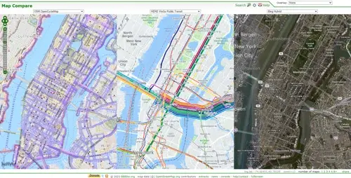
Map Compare is an IMINT tool that gives you access to dozens of different map types and allows you to compare them side-by-side. For example, the picture above shows New York City from 3 perspectives: bike paths/lanes, public transit routes, and a satellite image.
Before you do a risk assessment, you can use this tool to look at different map types and better understand the environment the property is in. This can give you and your security guards a better idea of what types of potential risks and threats to look for during the risk assessment process.
2. Google Earth
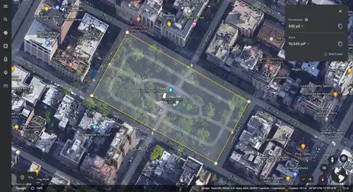
Google Earth is a simple IMINT tool that is very useful for planning risk assessments. You can draw on the map, start mapping potential guard tour routes, and even take measurements like in the picture above.
Because of the enhanced imagery that Google Earth offers, it can look very good on customer-facing risk assessment reports and communicate a high level of professionalism.
3. Crimemapping.com
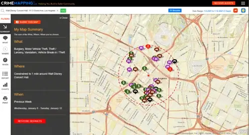
This website combines Open-Source and Imagery Intelligence in a clear and useful way. Set the “what, where, and when” to see the crime trends that are happening near a property you cover.
This map gives you as a security professional an understanding of what kind of crime is happening in an area. By including it in client reports, you can help them see the issues going on around their property. This can be especially useful when you need to update your security plan, service offerings, or even bill rates because the client will clearly see where the problems are.
4. Citizen
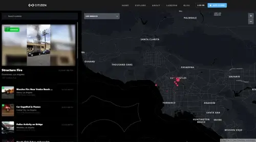
(NOTE: Citizen is currently only available in major cities. Skip down to the next section for a similar tool.)
Citizen combines all 3 types of intelligence gathering. Regular people use Citizen to report incidents happening near them like a structure fire or police activity.
The likelihood of any of the incidents happening on the property you are hired to protect is unlikely. But it’s helpful to know what’s going on in the area around it if those incidents end up affecting the property or people on it.
5. OSINT Combine
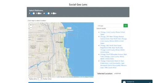
OSINT Combine is an Open-Source Intelligence website that offers a wide range of intelligence gathering tools. This tool, called the Social Geo Lens, allows you to search through geo-tagged social media posts on Facebook, Instagram, Twitter, and Snapchat.
You can see what people are saying about the area generally or if any specific incidents have occurred. This can be useful after an incident has occurred near a property you service to see what potential threats still exist.
Why Ongoing Intelligence Gathering and Risk Assessments Matter
When bidding a new security contract, intelligence gathering and risk assessments are very important. During the bidding stage, odds are you won’t know much about the new property, and it’s even more likely that you’ll still be trying to understand the client’s wants, needs, and concerns.
Gathering information about a new property will set you up to perform your security services better from day one. But many physical security companies don’t think about intelligence gathering and risk assessments after they’ve won a new contract.
In fact, ongoing intelligence gathering is just as important as the initial risk assessment. As you implement your security solutions, the security risks will shift and change. Current events, changes in the demographics of the neighborhood, and seasonal events can all influence what specific risks a property might face.
By doing regular security risk assessments and gathering intelligence consistently, you will set your security services up to be more adaptable and show your clients that you are evolving with them and their needs.
Frequently Asked Questions
Latest Articles





Featured Resources
See Trackforce in action
Book a walkthrough with our team and see how it fits your operation.